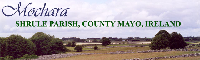
The Townland and Village of Mochara
Mochara is a townland in Shrule Parish
in southern County Mayo near the Galway border,
about 10 miles south of the town of Ballinrobe.
In 1271 Shrule was known as Sruthra
meaning "a stream or current".
The townland of Mochara is in the northwest section of the parish and abuts the parish of
Cong on the West and the parish of Killmaine on the north.
Variations in spelling over the years include: Mohorra, Mughorra, Mocorha,
Mochara, Mohara, Mohorra, Mackarroe, and Moycharry.
According to Martin Noone, our guide to Mochara in June 2000, it means "my cousin" in
Gaelic. According to Peter Mass in Father and Son (a novel), Mo chara means
"My friend".
However, the origin of the name comes from "Magh Cartha"
meaning "plain of the standing stone".
Census information indicates the following population for Shrule:
- 1841 - 729
- 1851 - 590
- 1871 - 330
- 1891 - 246
- 1911 - 205
showing a steady
decline in the population from 1841 to 1911.
Shrule parish suffered a loss of 139 people
between
1841 and 1851 (This included the years of the Great Famine, 1845-1849). This is a surprisingly
low
decline in population for
western Ireland
where thousands died of hunger and disease during the famine and thousands of others emigrated.
There were several aspects that contributed to the low death/emigration rate from Shrule
parish during
the famine years:
- Sympathetic Catholic landlords, who did not evict tenants for lack of rent
and who made large
concession to rent payments. Some of these landlords ultimately lost their
lands as a result of their famine policies.
- A large amount of "corn" (wheat) was grown in Shurle parish.
It was locally milled and distributed to the population.
- Alternative crops, like turnips, were grown.
- Local relief boards and landlords provided provided work relief like ditch
digging and wall building.
You can still see relief walls today. They are much higher than any wall needs to
be to keep cattle and sheep from
roaming.
While there were few deaths in the parish from hunger, many died from epidemic
diseases like famine fever and cholera. In addition, many people left
the land and emigrated.
During the early part of the 18th century there was a move
to convert the land in the area from tillage to grazing. Tenants opposed the evictions
that came with
this change in land usage by maiming and killing the landlord's livestock.
In January 1712 it was reported that
300 head of cattle had been killed in Mayo during the second week in January.
Other forms of agrarian protest by the Catholic tenants included stealing sheep and crops.
This area was noted as being a predominantly Gaelic speaking part of the country.The 1901
and 1911 censuses confirm that everyone in the village was Gaelic speaking or
bilingual Gaelic/English.
Go to Photos of Mochara
now or at the bottom of the page.
Archaeological Sites in Mochara
An Archaeological Survey of Ballinrobe and District produced by
Lough Mask and Lough Carra
Tourist Development Association 1989-1992 lists three archaeological sites of interest in
Mochara:
- A standing stone, "In level pasture. Rectangular in cross section.
Height 1.2 meters, Width .04 meters."
Standing stones were markers for graves,
boundaries, routeways, or to commemorate some important event. They have been
erected from megalithic times to the present.
- A holy well, "In wettish pasture".
The Lough Mask and Lough Carra Tourist
Development Association listed the well as being "shown" on the Ordinance Survey Maps
of
1838 and 1929 as Tobersharve.
The well was not located in the field work done by them.
When Penelope Berren (Byrne) married Mathew Langan
in the Roman Catholic Chapel of Shrule, on June I, 1865 she
was listed as the daughter of Michael
Byrne,
poor tenant, Tubbersharre.
Well veneration was a widespread and ancient tradition in Ireland.
The water was connected with cures and was not used for personal consumption
or watering livestock.
- "Mochara Castle", according to the Lough Mask and Lough Carra Tourist
Development
Association was really a "tower house". It is described by them
as a
"Rectangular tower (12.3 meters North by South, 10.1 meters East by West,
on North facing slope, in pasture. Ground floor survives; filled with rubble and roofed by
poor remains of vaulted ceiling. Ground floor divided into two rooms, the smaller one on the
South end. Part of splayed window in an arched recess on external face of West wall.
Owned by Brian boy Mac Donnell in 1574."
Go to Photos of Mochara
now or at the bottom of the page.
Landlords
Browne/Dillon
From Landed Estates
"(Estate) Browne/Dillon-Browne (Glencorrib) - A branch of the Browne family of the Neale,
barony of Kilmaine, county Mayo, settled near the village of Kilmaine and were generally
known as of 'Ellistron' in the 18th century. In 1681 Valentine Browne was granted over
2,000 acres in the baronies of Kilmaine, Carra, Gallen and Tirawley, county Mayo with
lands in counties Galway and Clare. In the 18th century the main part of the
estate was in the parishes of Kilmainemore and Shrule. Two of the townlands
belonging to them in the parish of Shrule, Mocorha and Bunnafollistran, had been
sold to Sir Walter Blake in September 1699 by the trustees for the sale of the estate of
Colonel John Browne of Westport. Robert Browne of Ellistron, parish of Kilmainemore,
had a son Arthur who lived at Turin in the early 19th century. By the time of the first
Ordnance Survey the Brownes were living at Glencorrib in the parish of Shrule.
The last member of the family to reside at Glencorrib was Robert Dillon Browne,
Member of Parliament and well known duellist, who sold the Browne estate
in the barony of Kilmaine and the Holywell estate in the barony of Costello,
county Mayo, in the early 1850s. The Glencorrib estate was bought by the
Higgins family of Westport and James D. Meldon and the Kilmaine lands by Robert
Tighe and Robert Fair. In 1882 over 150 acres in the baron of Longford, county
Galway, the property of Arthur and Anne Dillon-Browne was offered for sale in the
Land Judges court. In July 1882 the Irish Times reported that the Court had
been informed that the tenants on the estate were willing to offer a total
of £1106 to buy the property but that the owner sought a bid of up to £3000.
The sale was adjourned."
The Browne family had a great house at Glencorrib. Their estate included the villages of
Mochara, Cahir, Bunnafollistran and Ravenhill. Arthur Browne married Mary Kirwan. They had one child, Robert Dillon Browne.
Robert died bankrupt in 1850.
The House of Commons, as Elected to the Fourteenth Parliament of the United:
"Browne, Robert-Dillon: son of the late Arthur Browne, Esq., of Glencorrib, co. Mayo;
first returned for the county on the Rt. Hon. Dominick Browne being created Baron Oranmore,
May 1836, when he was proposed by Dr. M'Hale, Catholic Archbishop of Tuam; a Repealer;
descends from the Kilmaine family; is cousin to the Countess of Ripon, and nephew of
Thomas Martin, Esq., M.P. for Galway co."
Robert Dillon Browne son of Arthur Browne and Mary Kirwan died in 1850
The Gentleman's Magazine, Volume 34
"July 1. In London, in his 39th year, Robert Dillon Browne, esq. M.P. for the county of Mayo.
He was the son of Arthur Browne, esq. of Glencorrib, co. Mayo; and was first elected to
Parliament for that county in the year 1836, in the place of the Right Hon. Dominick Browne,
then created Lord Oranmore and Browne. He was invariably found among the most liberal
supporters of the Whig government. Mr. Browne was in the enjoyment of his usually
excellent health until Friday the 28th June, when premonitory symptoms of gout
developed themselves. On that evening, contrary to the advice of his medical advisers,
he attended in bis place in the House of Commons for the purpose of recording his
vote in favour of Lord Palmerston's foreign policy, and there is little doubt
that the excitement and exposure to cold necessarily consequent on that step,
tended to aggravate the illness with which he was threatened. On the following
day he was seized with a violent attack of gout in the head, which terminated fatally.
For some time previous to his death he was busily engaged in asserting his claims
to the dormant Irish peerage of Roscommon.
Mr. Browne was an accomplished classical scholar, and a very able speaker.
As a popular orator he had few superiors, and, though he spoke but seldom in the House of
Commons, he never failed to command attention and respect."
The house at Blencorrib passed to George Gore Ouseley Higgins M. P. of Glencorrib and Mount Pleasant. He
was born 15 October 1818 and was High Sheriff of Mayo in 1868.
The house at Glenncorrib is not longer standing.
William Brannick, Esq.
William Brannick Esq. was listed in the 1825 tithe applotment in
"Mocorrow" with 222 acres. There were four other people listed: John Fitzpatrick (60 acres),
Anthony Noone (4 acres), John Higgins (5 acres), and Patrick Murphy (16 acres)
"At the time of the first Ordnance Survey the Brannicks were leasing land from
David Watson Ruttledge in the parish of Robeen and from Arthur Browne in the parish of Shrule, both in the barony of Kilmaine, county Mayo. The Brannick family owned Annefield in the 20th century."
(Landed Estates)
James Dillon Meldon
James Dillon Meldon was a Dublin lawyer.
Meldon - Landed Estates
1847:
James D. Meldon, 14 Upper Ormond quay., Dublin
1951:
James D. Meldon purchased property in Mohorra in 1851 under the Encumbered Estates Act.
See above - Robert Dillon Browne who died bankrupt in 1850.
James Dillon Meldon a Catholic, of Merrion Square Dublin and Coolarn, Athenry in Gounty Galway married Bedelia Ingram. They had seven sons and nine daughters:
John James, James Felix, Charles Henry, Austin, "Sir" Albert, Lewis, Joseph, Mary Susan, Susan Elizabeth, Bedelia, Juliana Louise, Bedelia Frances, Jspephine, Mary
Teresa m Agnes, and Mary.Several of the children died in childhood.
James Meldon built a shooting lodge at Coolarne in 1865 on his 2,351 acre estate.
Coolaren is south of Tuam.
Griffith Valuation 1857:
James D. Meldon 603 - 308 acres for his own use.
1a, in fee, land and herd's house , 308 acres.
4c, in fee, yard and offices (0 0 16) Note: I don't know how big this property was but it was well under an acre.
Immediate lessor for all the remaining properties in Mohorra
James Meldon was the landlord of other properties in Ballybackagh in Kilmainebeg Parish, County Mayo.
1857: Ireland, Griffith's Valuation,1857:-
James D Meldon
- Caherateemore, North, Lackagh, Galway, Ireland -hers house 552 acres in fee
- James D Meldon
- Caherateemore, South, Lackagh, Galway, Ireland - land house anf land 42 acres
- James D Meldon
- Lissaleen, Kilbennan, Galway, Ireland - herds' house. office, and land 227 acres
- James D Meldon
- Belmont, Liskeevy, Galway, Ireland - Land, house, offices and garden 3 acres - land 16 acres
- James D Meldon
- Mocorha, Shrule, Mayo, Ireland - 308 plus acres
1862:
Louisville, Ky Daily Journal
Mr. James D Melson of County Galway has purchased
100 tons of Indian meal for distribution among the poor on
his estates at Belmont, Coolnenn and Turlonghmore.
1874:
"We shall now describe the system of management pursued on a portion of his
estate in the Co. Galway, by J. D. Meldon, Esq., of Dublin. The whole extent in
hand is 1,700 statute acres, divided into three holdings: namely, Coolarne and Cahertimore,
situated five miles north-west of Athenry, containing 1,450 statute acres, of which
1,250 are always in pasture, and the remaining 20O acres are under a course of tillage.
Oranmore, containing 100 acres of good land, all in grass, is situated four miles to
the east of Galway town ; and Belgard, situated near Kilcock, Co. Kildare, within
twenty minutes' drive by rail of Dublin, contains 150 statute acres of very rich
fattening land. Both Oranmore and Belgard are mainly used for fattening
the sheep bred and reared at Coolarne. 4-40. The lands of Coolarne and Cahertimore,
originally the estate of a nobleman, had been formerly let to small tenants under
the Court of Chancery, and were badly farmed. The famine years and the Chancery
ejectments left the lands tenantless. Mr. Meldon then purchased the property
in the Landed Estates Court. The greater part of it was covered with heather.
Immediately after obtaining possession he commenced to reclaim the coarse
and inferior ground. The heather was cut away with the scythe or hook, and
carted into the yard for bedding cattle, or for being put under manure heaps.
A piece was fenced in at once, all rough stones removed from the surface,
and then let in small plots of an acre or half-acre to the labourers
of the surrounding districts, the rent being the cost price of the
Peruvian guano with which it was manured, at the rate of 6 cwt. per statute acre.
The owners of these plots turned over with the "log" (or long spade)
the tough sods which would have resisted any of the ordinary implements
of cultivation. On this sod they planted the potatoes, and covered
them with clay from the furrows. The proprietor supplied those
that had not good seed of their own with all they required, at
market price, giving them till November for payment. The furrows
were deeply trenched in moulding the potatoes. After the crop
was dug, the land got a good ploughing,
......... continued
Introduction to Irish Farming
Did the Meldons change the farming habits at Mochara?
The Meldons did have fox hunts ar Coolarne.
1876:
The "Returns of Owners of Land of One Acre and Upwards" listed James Dillen Meldon at 14 Upper Ormondquay, Dublin. He was listed as the major landlord in Mohorra in the Griffith that covers the year 1876. There were no "Owners of Land" listed with a Shrule address. James D Meldon was still listed as the "Immediate Lessor" in the 1883-1897 Griffith ledger.
1878: J. D. MELDON and SONS, 14 Upper Ormond-quay.
John Meldon, Louis Meldon, James Meldon, and John M. Meldon,
Solicitors listed at 14 Upper Ormond Quay in 1905 (Oaths Meldon & Co. (John Meldon,
Louis Meldon, James Meldon, and John M. Meldon), Solicitors, Practitioners in all
Superior Courts, also Probate, Admiralty, and Bankruptcy Courts, 14 Upper Ormond quay)
1887: The estate of James Dillon Meldon was valued at £100,000 - named as trustees
were his widow, Bedelia,
and his youngest son, Joseph - 800 to 900 ares of land in Galway including a house called Coolarne,
1889" 24 Merrion Square North the residence of
the Late James D Meldon esq was for sale - contained 2 large drawing rooms,
(27x21 and 27x19) with bay windows and balconies facing the square, large dining room, study,
breakface parlour, tilled hall, billards room, private chapel, 8 large and "airy" bedrooms,
bathrooms, lavatories, and WC, hot and cold running water, gas, mahogany doors throughout,
kitchen with "close range", hot water boilers,
wine and beer cellers, china, glass, wine and butlers pantries, male and female
servants bedrooms, housekeepers room, store and boot rooms.
Also included: out offices, 3 loose boxes, 3 stall stables, cowhouse, coachhouse, large yard, mens rooms (3), harness rooms and large hay and straw lofts, greenhouse.
The property was for rent in 2016: Ground floor 1,776 square feet,
First floor 1,765 square feet. Total accommodations 7,405 square feet.
See Landlords
Land Purchase Acts
The Land Acts were a series of measures instituted between 1870 and 1909 to resolve the question of the
Irish peasants right to the land.
The Land Purchase act of 1903 allowed tenants to make land purchases at a reasonable rate.
1901/1911:
The 1901 and 1911 the censuses in Mochara indicate the "landholders" were
mostly the same as the families who had been
living in the dwellings for some time.
www.shrule.com is one of the best genealogical
sites on the internet.
|